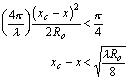
By assuming that the Doppler frequency shift is constant only until the quadratic term adds a value of  / 4 to
  , then the window for observing the waveform is confined to a distance of xwindow, where
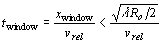
and so

Therefore the time window is
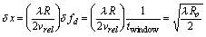
Therefore, the new azimuth resolution is
A SAR processor which uses this technique is known as unfocused SAR. This technique does not account for the variable rate of phase change, but still manages to produce a resolution much smaller than that for real aperture radars. For example, using the above equation, the resolution for RADARSAT would be
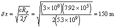
as opposed to the real aperture limit of 3.0 km.
The
resolution can get even better, however, by using a focused SAR
processor which accounts for the nonlinear phase change. This technique
uses all the data collected during the time that the target is within
the beam. The quadratic phase is adjusted such that all the return signals due to the target at x0 (see Figure 9) are added coherently. Any returns from targets not at x0 will not agree with the adjusted returns so they will cancel. Thus the returns from the target at x0 will dominate the returns from other targets with the same range but not at x0. With a few assumptions, this technique results in an azimuth resolution approaching La / 2, which is what we calculated before, assuming a constant phase.
At first glance, a SAR image may seem to closely resemble an optical image. Closer inspection, however, reveals striking differences which can be used, given knowledge of how radar interacts with ground features, to provide a wide spectrum of information about the targets. The most obvious difference from an optical image is the geometric distortion produced due to the depression angle and the height or slope of the target.
When terrain is imaged using an optical sensor such as a camera, the image can be thought of as a central perspective projection--all of the terrain points have projection lines passing through a central point on their way to their corresponding image points, as in Figure 10a. The situation for a SAR is very much different, however, in that ground objects will be placed into locations on the image line as a function of their distance from the antenna--not as a function of their distance from each other on the ground. Figure 10b shows that the projection lines are concentric circles around the antenna, due to the spherical spreading of EM pulses.
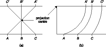
Figure 10. Image projections for (a) optical and (b) SAR imaging systems.
Suppose you are imaging objects A and B, separated a distance on the ground, as shown in Figure 11. Because the SAR is viewing from an angle, the two points will look closer together than they actually are. Since angle ACB is approximately 90o, we can say that Dg in slant range presentation is

so
that the distance in slant range presentation is always less than in
the corresponding ground range projection. As the depression angle  gets larger, Ds gets smaller for a given distance Dg.
Thus the slant range presentation compresses the terrain features in
the near range more than in the far range. This has the effect of
greatly stretching the ground range projection near the nadir where approaches 90o.
gets larger, Ds gets smaller for a given distance Dg.
Thus the slant range presentation compresses the terrain features in
the near range more than in the far range. This has the effect of
greatly stretching the ground range projection near the nadir where approaches 90o.
Figure 11. Image of points A and B in slant range and ground range presentations.
The ground range presentation is used when one wishes to match the image with known target locations (i.e. geocoding the image) on the ground. EarthView is able to convert an image from slant range to ground range and visa versa, taking into account the curvature of the Earth for satellite imagery.
Imaging a target on top of a vertical structure height h above the ground results in a relief displacement, that is, the target is displaced a distance of rs in the original slant range presentation of the image, as shown in Figure 12.
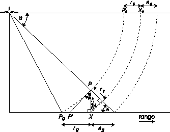
Figure 12. Relief displacement due to a vertical structure.
The relief displacement rg is equal to the distance  , however for a small enough value of h, we see that PgX
  P'X. Thus we can estimate the relief displacement in ground presentation as

and in slant range presentation as

Thus the relief displacement is proportional to the height of the vertical structure and increases the closer that structure is to the nadir line.